22-kilometre 2012 Mt Glorious mountain trails race. Saturday, 4th February.


The presentation to the winners happened well before I finished. But I enjoyed the lunch of sandwiches, fruits and other food goodies provided at the finish line. Well done to the RD Greg, TRAQ organisers, volunteers and everyone involved. Maybe next year, 100 of the runners should use the bus (mini-buses?) and the other 50-60 may use their cars. As the bus driver said 40-80 cars away from those mountain roads can only do good. Runners can just relax pre- and post race, with less damage to the road system, less risk of accident, less need for parking space, and good for the environment. See, increasing your running footprint, lessens your carbon footprint. Now I’d definitely do Mt Glorious again next year, but only if TRAQ can arrange for a beach and pool at the finish line :-).
Mt Glorious on the northwest of Brisbane is a
popular destination for those seeking an escape from the hustle and bustle of
city life. A cool retreat in summer, the mountain has rainforests, walking
trails, viewing spots, picnicking places, birdwatching and many other
activities. Walkers and hikers are spoilt for choice with paths of varying
grades: Maiala Park short walks with parking, picnic and toilet facilities, rainforest
trails and tracks with loops and circuits and climbs to peaks and descents to
creeks, and the odd swimming hole. I now know of two. I’ll have seen them and waded
across them in a biathlon (aquathlon) today. There’s also the longer and steeper trails, used for fire management, forest ranging or for the
occasional trail walk hike trek or even run. One such summer trail run is the 22-kilometre 2012 Mt Glorious
mountain trails race.
The final weeks of summer in Queensland are in
February. It’s the best of times, and the worst of times – for running and hot
weather.
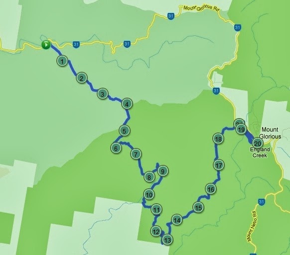
 |
| Map of the route. |
The first Saturday of February was fairly
typical. Temperate early morning with expected high humidity and mercury may be
rising. The clouds in the sky seem uncertain on what to do, linger or go. I was
uncertain also on my running battle armour. I gathered up the necessities:
hydration pack, cap, watch, phone, energy bar, water bottle, camera, spare
socks, footpads and shoes. It all appeared bulky and heavy, and that’s without
sunscreen. I looked at what I can leave behind, maybe the tiny plastic bag for
the mobile phone (in case of rain). Then I thought if some people can run
barefoot, maybe I can run butt naked. But I feared getting sunburnt, and the
ladies might burst out laughing. Wear a g-string perhaps. This conundrum was
all too hard to fix so I just upped and went.
I drove to The Gap to catch the runners' chartered bus to
Mt Glorious. I was expecting more runners than turned up. Others obviously
decided to use private transport. The bus left at 06:05 up Waterworks Road
towards Mt Nebo. I was looking forward to viewing parts of the D’Aguilar range
national park on the drive up. However the bus turned left to Payne Road and I
thought we’re taking the bumped-up Gap Creek Road on the edge of Mt Coot-tha. But the bus turned
again and I realised finally that it was not suited to the narrower ascending and winding
mountain roads and is taking the long way around, going anti-clockwise to Cedar
Flats. So leaving The Gap, we go through the northwestern suburbs: Ashgrove,
Bardon, Red Hill, Paddington, and Toowong. And then along the western freeway,
Ipswich motorway, Warrego highway thence past Fernvale to Northbrook parkway,
venue of the start line at the base of Northbrook mountain.
We arrived there around 07:15. The atmosphere was carnival-like, with a band
of bagpipers and bright sunshine greeting the runners and their supporters. The
entries are limited to 150 or 160, but there seemed to be twice that number. The
wilderness had come to life right there on the side of that deserted mountain
road.
The sun was up and smiling at the runners. I
just hoped it did not get too warm.
 |
| There was no mist. The fuzz was from my camera. |
The runners were sent off in three waves about
five minutes apart. The faster runners were in the first group and soon the
bagpipes called them to arms, or to legs, I mean to ass-emble. Each group was
briefed separately just before the get go by the race director. Greg Waited
patiently for the boys and girls to lend their ears.
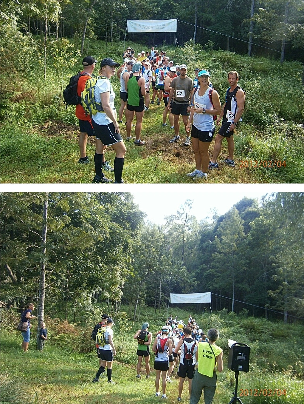
And then the first wave of runners scooted off.
The second and third groups followed soon after.
Just metres from the start line, we come to a
crossing on a creek swollen from all the rain this wet summer. It was at least 5m wide with water up to knee deep and no way around. Runners had no choice but to wade across.
Once across the creek it was all steep hill
climbing (about 450m ascent over 3.75km) to the top of Northbrook mountain.

The trail was tough and the tough runners got going–
if only I was one, but I was just rough, and doing it the toughest. Like on
many previous runs, I brought up the rear, guarding the runners from leeches
and snakes, or was it just my imagination. I was actually avoiding getting
trampled while ruing my sodden shoes.
From the hilltop on Mt Northbrook, the course
flattened out and then we started descending down the long, winding, rolling zigzags
towards England Creek. There were speed bumps (some were mole hills bigger than
mountains) along the descent but I finally got to the creek at about the 10km
mark.
From here it’s a mere 600m of climbing over
12km to the finish. This uphill battle is very daunting really. If only I had a
car.
But wait I see a 4WD! This was at the watering
station where I replenished my water bottle. A daddy and three young kids cheerfully
and efficiently attended to the runners. The kids were having fun helping dad with
the drinks and lollies. Good on you all.

The next 3km section of the trail along the
creek was relatively moderate, but I was inclined (psyched, conditioned,
brainwashed) to walk anything remotely resembling an uphill. I trudged on with
my feet getting more and more uncomfortable with every step, as mud sweat and grit dumped on my shoes that were already damp from the start.
The next watering point near the 13km mark was a relief. The couple attending the water station offered encouragement
and nice words to all: ...more than halfway
there it’s all downhill from here, one more water stop, wonderful run in the
rainforest... Where would running events be without volunteers? I cannot thank
volunteers enough in words (especially when huffing and puffing) but it’s
wonderful that they’re there.
Again I watered up. Then I took a breather,
and changed my socks and footpads for the final 9km ascending leg of this
journey. I counted about 20 runners go past as I rested up. They’re hardly
sweating. All along the route runners had been passing me, on average one every
500m. I did pass one or two - at the water stops.
The sun was peeking through
the clouds again as I resumed battling up the mountain. A runner sprinting up
the hill asked how far to go. I was almost dead and out of breath and did not
really want to know how much more i had to endure. But I checked my watch and politely
told him: another seven-odd kilometres.

I passed the last water stop at KP18, and then after what
seemed like an eternity of torturous uphill hiking, I somehow got to the verge
of the rainforest at the mountaintop. It felt like another world. The air was
cooler and thinner. The thicker vegetation blocked off some more of the
daylight, and jogging under the canopy with the dimming of the day, was like running
in the evening with the darkening of the night. Surreal but so real.
 |
Multiple choice: a. the photographer's hands were shaky. b. the reader needs glasses c. both of the above |
Soon the TRAQ red arrows at the stone-lined single track
appeared and I entered the muddy winding trail. The woods are lovely dark and deep, but I have promises to keep, and
less than a mile to go before i slip - out of the thick trees, to the sunny grassed
clearing at the finish in Maiala park.
So I slowed down
taking great care not to slip. Some of the best rainforests in Australia are
right here in Mount Glorious with strangler figs, buttressed trees, stinging
trees and large rainforest trees. However the rocks
and protruding tree roots make the gloomy trail uneven in places. Treading
cautiously, I hurried slowly through the wet sclerophyll and rainforest,
past the western window, ducking under branch and overhanging vine, until I
finally come out to bright sunshine at the finish line.

This was indeed a
mountain trail, and for good reason. I think I finished just outside the
estimated average finish time. Below-average for me,
but then this was no ordinary run. This was tough as tough can get. The cloud
cover did hover above all day, keeping the intermittent warm sunshine at bay.
This helped my cause immensely because I usually just melt in the sun. And the
shade provided by the canopy of the gums and then the sanctuary of the rainforest
kept me from wilting.
The presentation to the winners happened well before I finished. But I enjoyed the lunch of sandwiches, fruits and other food goodies provided at the finish line. Well done to the RD Greg, TRAQ organisers, volunteers and everyone involved. Maybe next year, 100 of the runners should use the bus (mini-buses?) and the other 50-60 may use their cars. As the bus driver said 40-80 cars away from those mountain roads can only do good. Runners can just relax pre- and post race, with less damage to the road system, less risk of accident, less need for parking space, and good for the environment. See, increasing your running footprint, lessens your carbon footprint. Now I’d definitely do Mt Glorious again next year, but only if TRAQ can arrange for a beach and pool at the finish line :-).

My reading of the results:
- Average finishing time: 2:50:00. About 80 runners finished under this time.
- The bottom 60 finished in an average of 3:15:00. I am bracketed in this group. Makes my time look good.
Congratulations to the top placers, but as I like to say, the winners are all the participants...
The top 15 are:
The top 15 are:
| Place | Class | AgeGroup | RaceNum | Firstname | Lastname | Clock |
| 1 | 1M | 20-29 | 82 | Gerard | Balnaves | 2:00:08 |
| 2 | 2M | 40-49 | 203 | David | Riach | 2:01:30 |
| 3 | 3M | 30-39 | 28 | James | Bamber | 2:02:01 |
| 4 | 4M | 20-29 | 107 | Daniel | Nunan | 2:02:31 |
| 5 | 5M | 20-29 | 11 | Ben | Malby | 2:09:45 |
| 6 | 6M | 30-39 | 102 | Artem | Golev | 2:09:46 |
| 7 | 7M | 20-29 | 87 | Jim | Heaslop | 2:09:47 |
| 8 | 8M | 20-29 | 64 | Josh | Magar | 2:10:46 |
| 9 | 9M | 20-29 | 216 | Steve | Whiteman | 2:11:32 |
| 10 | 10M | 20-29 | 94 | Henk | Morgans | 2:17:31 |
| 11 | 11M | 30-39 | 8 | Terry | Verhaar | 2:13:45 |
| 12 | 1F | 40-49 | 205 | Hubertien | Wichers | 2:14:06 |
| 13 | 2F | 30-39 | 24 | Lucy | Blaber | 2:16:56 |
| 14 | 12M | 40-49 | 202 | Nigel | Waddington | 2:16:56 |
| 15 | 3F | 20-29 | 70 | Kirra | Balmanno | 2:18:04 |
+(1280x960).jpg)
+(1280x960).jpg)
+(1280x947).jpg)
+(1280x1000).jpg)
+(1280x964).jpg)
+(1280x977).jpg)
+(1280x972).jpg)
+(1280x1004).jpg)
+(1280x960).jpg)
+(1280x1010).jpg)
+(1280x951).jpg)
+(1280x1086).jpg)
+(1280x968).jpg)
+(1280x992).jpg)
+(1280x1000).jpg)

+(1280x960).jpg)
+(1280x977).jpg)
+(1280x1037).jpg)
+(1280x960).jpg)
+(1280x987).jpg)

+(1280x1022).jpg)
+(1280x988).jpg)
+(1280x1070).jpg)
+(1280x1047).jpg)
+(1280x960).jpg)